This independent TEDx event is operating under license from TED

Archive for the ‘Expedition’ Category

Should it Be a Felony to Cover the Oil Spill?

Friday, July 2nd, 2010

Reposted from TEDxOilSpill Expedition member James Duncan Davidson’s blog:

The Coast Guard has set up newer and tighter restrictions in the Gulf. Ones that would have prevented the TEDxOilSpill Expedition team from getting some of the photos we took. In short, there’s a 65-foot “safety zone” around any response vessels or booms on the water or on beaches. As reported by the Times-Picayune, violation can result in a civil penalty of up to $40,000 and could be prosecuted as a Class D felony.

Safety zones sound all good and fine if you’re nowhere near the disaster. But they also squelch coverage. Let me show you what the beach on Grand Isle looked like when we went out one evening after all the security and clean up crews left for the night:

Those dark blobs are tar balls. Weathered oil. Here’s what that same beach looks like a few days later during the day on the “safe” side of the barriers preventing access:

Can you tell what’s down at the water line? Maybe there’s something there. Maybe there’s not. What a difference that distance makes. This restriction is nothing but yet another chilling effect on top of all the others that are in place. Press photographers know how to work in dangerous situations. They know to not interfere with workers doing their job. They’ve done that in numerous disasters over the years of all kinds. They also know how to take responsibility for their actions.

Volunteers can’t work on the beach, ostensibly for liability reasons. Only contracted employees can go work. Of course, those contracts expressly forbid talking with media. Every boat captain that signs on with the clean up is also expressly forbidden from talking to media or taking photographers out, even when those photographers can stay out of the way of people working. Chilling effects, all.

The Coast Guard says that you must call the Coast Guard captain of the port of New Orleans to get permission. If you buy the safety argument, that sounds sort of reasonable. Except for the fact that there’s no stated rules for who can get permission. The Times-Picayune article reports that AP photographer Gerald Herbert—one of the few mainstream press photographers that has been putting out incredible shots—has asked to discuss the new policy with officials. Guess what? He hasn’t received a response.

Here’s one of my photographs that I could be convicted as a felon for taking now:

Here’s another:

Here’s another:

I successfully made these photos without endangering any response workers, interfering with boom, or endangering wildlife. In fact, there wasn’t a response worker within miles of my location. Should I be a felon for making these images?

Why is the government helping control the message here? Who’s interest is being served? It’s certainly not the public’s interest.

Expedition Expense Breakdown

Wednesday, June 30th, 2010

When I put out our call to ask for help funding the Expedition, I promised full and complete disclosure of what our expenses were and how we were putting your money to work. Not only did I figure this was the fair thing to do, but I also wanted to put a little transparency into what it takes to undertake an operation like this for educational purposes in case others want to try to do something like it in the future. Here’s the data:

Our recorded expenses in the Gulf of Mexico for the Expedition and to Washington DC to present our images and stories add up to $13,816.08. That doesn’t include the odd $1.00 toll or pack of M&Ms or beef jerky or batch of Cherry Limeades (yay, Sonic!) that didn’t make it into the accounting. It also doesn’t include a few expenses that I’ve not heard about from the other team members. But, it does include airplanes, cars, boats, meals, and lodging. In short, it’s almost the full accounting.

Here’s how it breaks out:

Airfare: $6,135.78. This is for flying five people to both New Orleans and Washington DC on short notice from various parts of the country. There’s no good way to take advantage of cheap fares when you’re on a deadline and when there aren’t any fare wars going on. Seaplane: $4275. This was for two flights out to the source with one returning via Barataria Bay and the other via Gulf Shores, Alabama. Hotels: $1732.06. Our most frequented stay was La Quinta. One night was at the Holiday Inn Express. Another was at a non-name place in Grand Isle, an amazingly hard place to find a hotel right now given all the workers staying on the island. The most expensive hotel nights were in Washington DC, of course.

Food: $751.45. This item came in much cheaper than I expected. Possibly because the Washington DC food expenses weren’t centralized. Mostly, we just ate very economically. I think our biggest splurge was a dinner at Chevy’s one night. Car Rental: $418.82 for our black Nissan Xterra. I’m sure the Hertz didn’t appreciate having to clean out the sand from all of our beach excursions. Gas: $168.92. Of course, we always avoided BP gas stations. Taxi: $160 for schelpping people around in Washington DC. Boat: $140. We didn’t spend much on big boats because none were to be found. All we were able to score was a flatboat. Still, we got a great deal on this. Ferry: $34 between Dauphin Island and Alabama.

The expenses tallied, lets look at the income side of the equation:

$6728.98 has been given through 140 donations as of June 30th. The average donation was $48.06. After PayPal fees of $248.44, that gives us $6480.54 to apply to our expenses. I’m currently working through the process of getting money out of PayPal right now, but I expect to have that taken care of soon.

If anybody was worried about funding our vacations after the TEDxOilSpill event, they don’t need to be. You’ll note that the expense balance will be $7335.54 after we get the current donation balance out of PayPal. We’re all still underwater by a good deal on this on out of pocket expenses. But there may be other opportunities to recoup some costs along the way. Furthermore, we knew the risks going in and are quite happy that the donations have covered as much as they have. For that, we thank you. —Duncan

If you’d like to help us out a bit more, please consider donating via PayPal.

“What have they done to the earth? What have they done to our fair sister?”

Friday, June 25th, 2010

20100618-tedx-oil-spill-1395

“From the air I could see 3000-5000 feet of black smoke… and what seemed like one fire was actually dozens of fires… recently heard a story of a captain who was rescuing sea turtles and realized that they were getting caught in the skimming nets that were being lit on fire.. the captain ended up checking up on the nets too much that BP let him go from his contract… the reality is that all kinds of wildlife are getting caught in the nets… and no one is getting them out before the burns.”

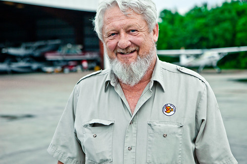
Photographer Kris Krüg, audio interview with Arjun Singh

20100618-tedx-oil-spill-1509

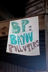
For over 60 days straight the Deepwater Horizon oil well has been leaking thousands of gallons of crude oil in the Gulf of Mexico. The tremendous amount of damaging has been stacking up the facts to register this event as a full on catastrophe for the Gulf and its coastal communities. No one has been spared when it comes to the effects of this leak. From wildlife habitats being destroyed, to fisherfolk being out of work for their fishing season, to dead marine life washing up on the beaches, there is something blatantly obvious about this situation: the Deepwater Horizon oil spill must be stopped.

20100618-tedx-oil-spill-1716

All of this cataclysmic emotion and frustration has fueled the organizing of TEDxOilSpill, an event taking place in Washington, DC on June 28th. This event will host a lineup of speakers who have emotional connection to the situation in the Gulf, including scientists, researchers, policymakers and photographers. The TED-inspired event will focus on the topics of energy policy reform, Gulf of Mexico marine life research and media collected from the TEDxOilSpill Expedition team. The Expedition team consisted of writer Darron Collins, photo editor Danielle Sipple and photographers Kris Krüg, Duncan Davidson and Pinar Ozger.

20100618-tedx-oil-spill-1315

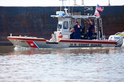
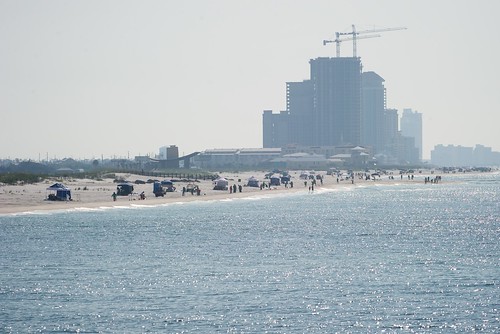
Bearing witness to the situation that is unfolding in the Gulf really puts into perspective the lack of comprehensive news coverage coming out of the area, with media blackouts, misinformation and coverups. Traveling along the Gulf coast lining Louisiana, Mississippi and Alabama, the team spoke to cleanup relief workers, displaced fisherfolk and local residents. Taking to the skies, they flew over the Southern Louisiana marshlands directly to the Deepwater Horizon oil well itself, otherwise known as ‘the Source’. Witnessing from an aerial perspective the oiled beaches, oil burns on the water surface, and a litter of tiny boats making very little progress against this immense spill was very disheartening. In fact news has just surfaced of an out of work fisherman in Alabama who committed suicide over the lack of effort in cleaning up the oil spill.

20100618-tedx-oil-spill-1665

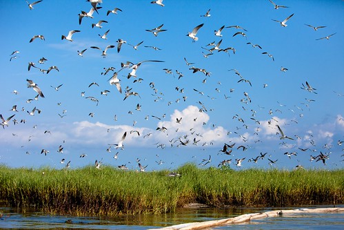
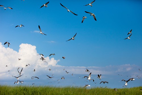
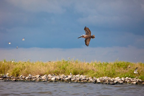
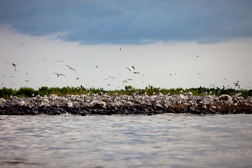
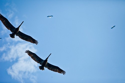
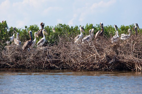
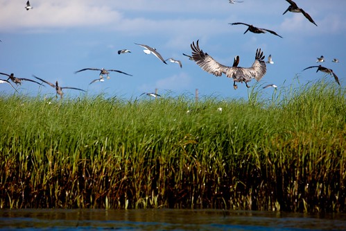
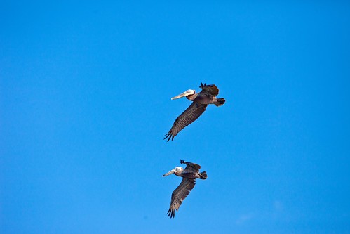
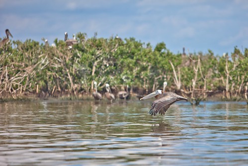
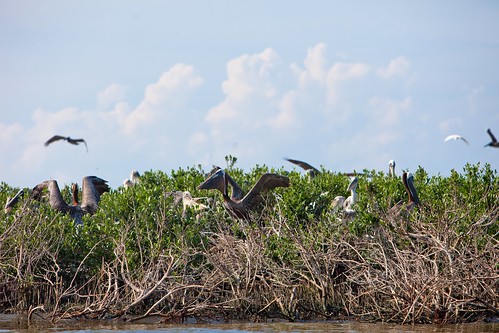
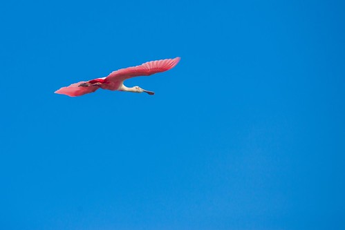
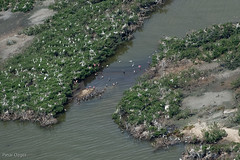
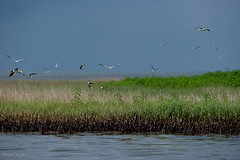
Dozens of small islands in the Barataria Bay marshlands are the homes and nesting areas to wonderful species of seabirds. Laughing Gulls, Brown Pelicans and even Roseate Spoonbills can be seen all on the same shore, with nests side by side. Unfortunately these small islands and these seabirds are getting hit very heavily by crude oil washing up on the shores and sometimes covering the seabirds’ feet, feathers and even their entire body. These islands are extremely remote which means getting to them can be very difficult in the cleanup attempts. Viewed from a boat ride led by an out of work fisherman, the islands were filled with dirty, forgotten boom and their beaches were absent from any sign of cleanup workers.

20100618-tedx-oil-spill-1955

Taking to the skies one last time was one of the best ways to grasp the true size of the oil spill. This flight proved to be an eye-opening journey into the depths of the actual size of this oil spill. Flying from the Source directly to the coastal area of eastern Alabama, the team discovered the shocking fact: the flow of oil from the Source was a constant slick all the way to the shore of Alabama. Slow and steady, a mixture of dispersant and crude oil was yards from beach lines that had people sunbathing in beach chairs. The most shocking realization was that everyone had bits and pieces of information, but really no one had any idea where it was going, when it was going to hit and who was safe.

20100618-tedx-oil-spill-1170

The expedition may be over but the emotional situation in the Gulf worsens as each day goes on. Cleanup crews work 24 hours a day in the coastal area while failed solutions are tried repeatedly at the Source. The size of the oil spill, the devastation of the constant leak and the cultural destruction of communities is overwhelming and saddening. The ironic scientific reality is that innocent marine life are being poisoned by their deceased ancestors in our glorified greedy actions. The only hope is that this is a wake up call for the greater situation at hand which is our dependency on fossil fuels. This hope comes at the price of so much loss. This is not okay.

Here are photos by Kris Krüg from the last seaplane journey to the coast of Alabama:

20100618-tedx-oil-spill-1236

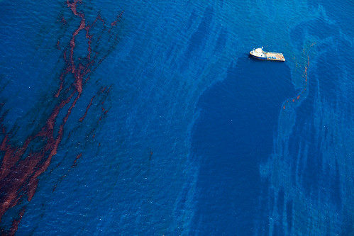
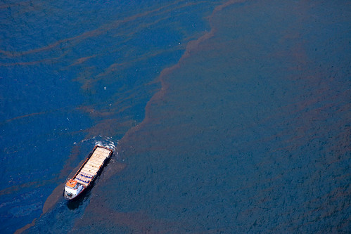
A boat involved in the cleanup effort in the Gulf of Mexico approaches a large patch of some extremely concentrated crude oil.

20100618-tedx-oil-spill-1550

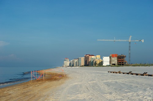
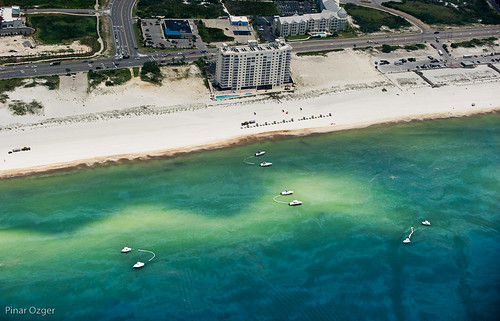
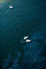
Just a few hundred yards off shore in Gulf Shores, Alabama, boats skim oil from the surface as the giant oil slick quickly approaches the tourist-filled beach.

20100618-tedx-oil-spill-1720

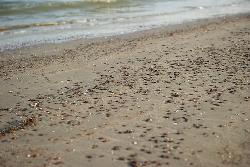
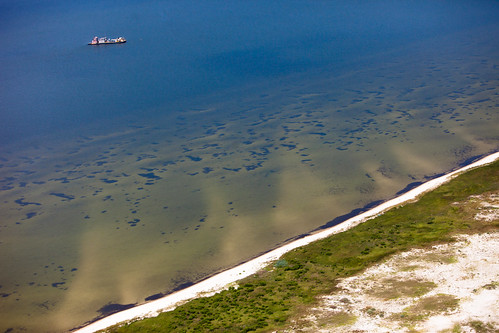
Large patches of dark crude oil gather along the water’s edge in coastal beach near Gulf Shores, AL.

20100618-tedx-oil-spill-1491

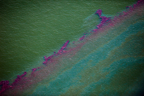
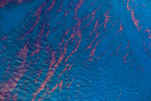
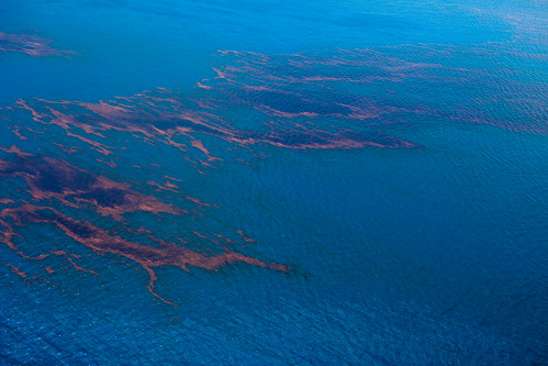
In parts of the Gulf of Mexico the crude oil collects together and appears dark red. This gives the appearance of blood which is not ironically lost on the fact that oil leak is more of a gash in the earth’s surface.

20100618-tedx-oil-spill-1085

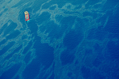
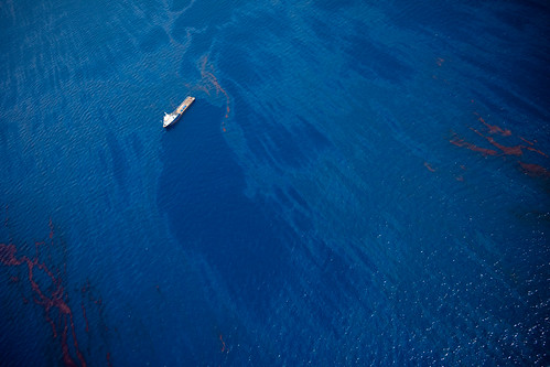
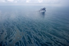
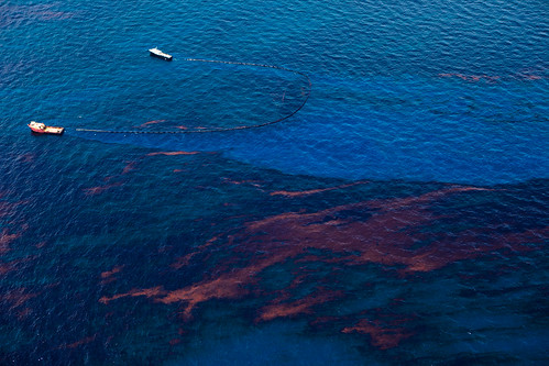
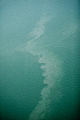
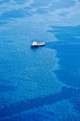
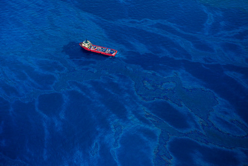
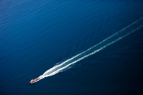
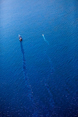
A lone boat wades through the blue water of the Gulf of Mexico. A small pathway can be seen where the boat has passed, pushing the oil to either side.

Sea Plane Captain Dickie

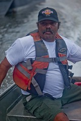
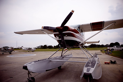
One of the ways BP controlled the media coverage of the oil spill was booking up virtually every available seaplane hour in the Gulf coast area. Luckily, our seaplane captain Dickie was fed up with how BP was trying to control the airways. A lucky situation arose which gave this rogue pilot complete flight clearance, even to the ‘Source’. Dickie and his seaplane was a rare find for the Gulf Coast during this time.

20100618-tedx-oil-spill-1193

Despite the fact that this is an underwater spill at 5,000 feet, crude oil is collecting at the water’s surface. The oil that is seen on the surface is a mere percentage of what lies beneath, at thousands and thousands of feet.

20100618-tedx-oil-spill-1798 20100618-tedx-oil-spill-1612 20100618-tedx-oil-spill-1882

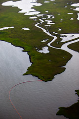
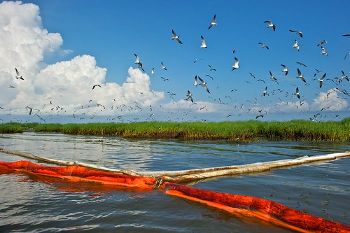
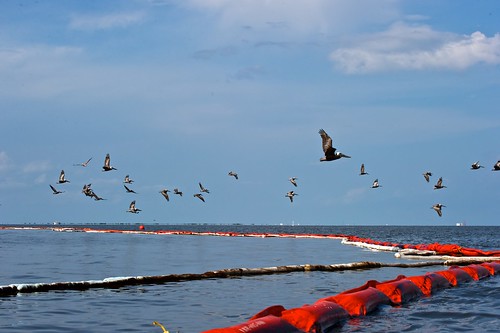
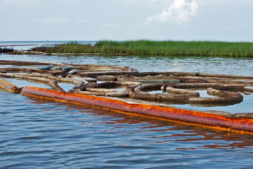
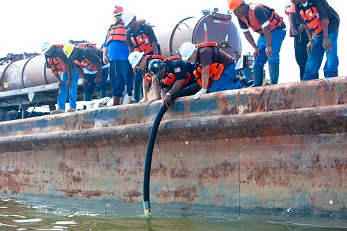
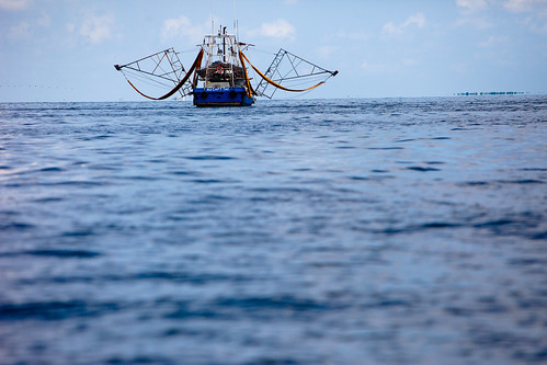
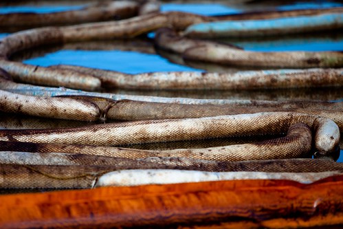
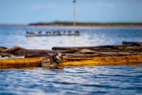
Some boom protects the open waterways of Louisiana marshlands; out of work fishing boats attempt to skim oil from the water’s surface; the oil slick is so much bigger than we can imagine or even see.

20100618-tedx-oil-spill-1305

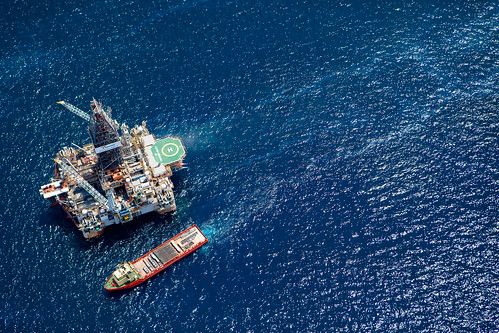
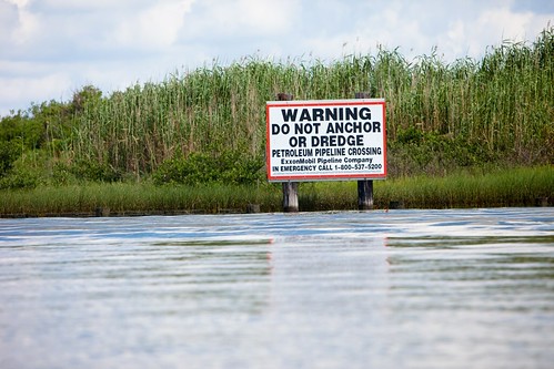
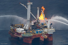
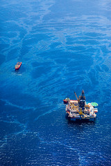
This is one of the relief well drilling stations in the Gulf of Mexico. These relief wells have been hailed as the solution to relieve pressure from the weakened and continuously leaking Deepwater Horizon well. Unfortunately completion for this project is slated for August, months after the initial leak.

20100618-tedx-oil-spill-1367

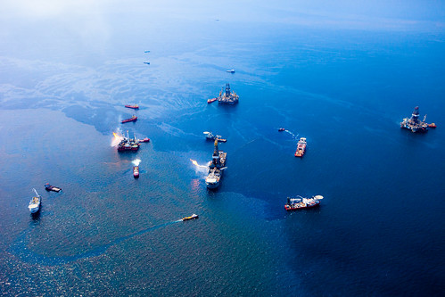
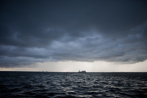
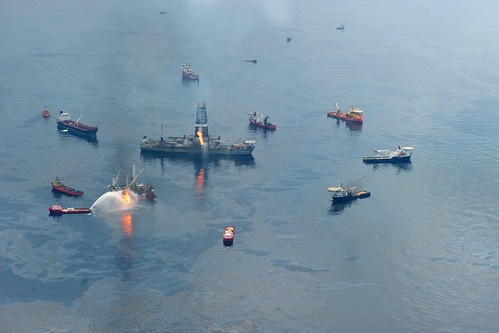
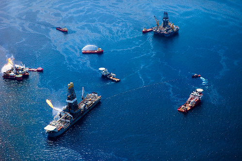
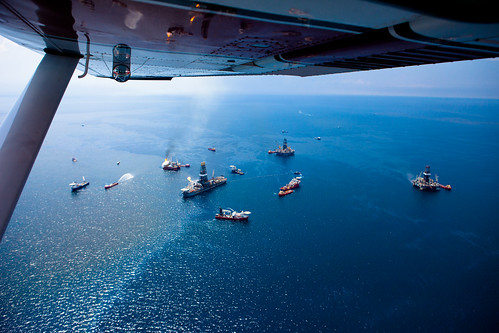
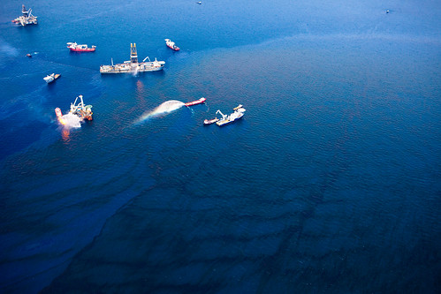
Oddly resembling a scene from the game Battleship, this is actually the Gulf of Mexico right at the source of the oil leak. Each massive ship, aiding in the relief or cleanup effort, looks tiny against the massive oily backdrop.

20100618-tedx-oil-spill-1634

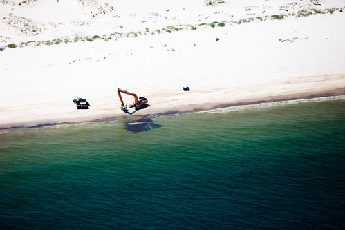
The best defense for the oil is literally to scoop it out of the sand and water. This large blob of oil lands upon the shores in Alabama which results in the need for the industrial size machinery.

20100618-tedx-oil-spill-1773

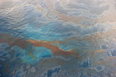
Iridescent oil streaks the beautiful aqua blue Gulf of Mexico. Once the crude oil mixes with the dispersant and starts to travel, streaks can appear like this.

20100618-tedx-oil-spill-1000 20100618-tedx-oil-spill-1101 20100618-tedx-oil-spill-0998

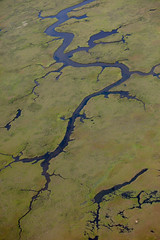
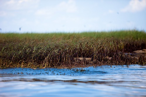
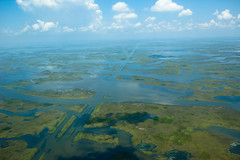
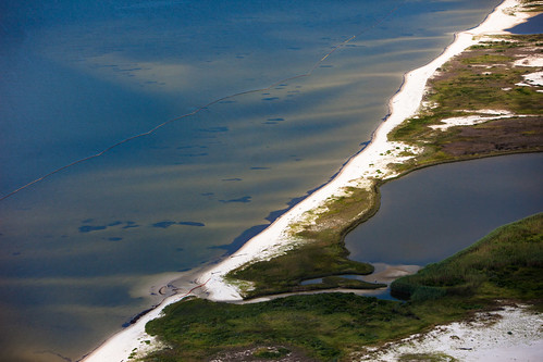
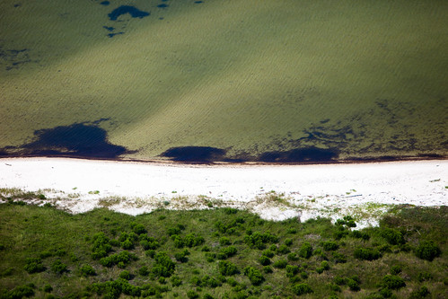
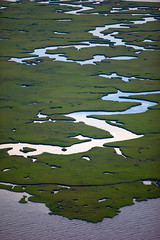
The beautiful marshlands of Southern Louisiana are being threatened and/or systematically destroyed by the Deepwater Horizon leak. Once oil hits the shores of the marshlands and coats the marsh grasses, there is really no hope of survival for the greenery.

20100618-tedx-oil-spill-1291

When the dispersant works against the crude oil leaking in the Gulf of Mexico, it essentially works the same as dishwasher detergent would work against grease. This unfortunately makes the surface water appear discolored and soapy looking.

20100618-tedx-oil-spill-1058

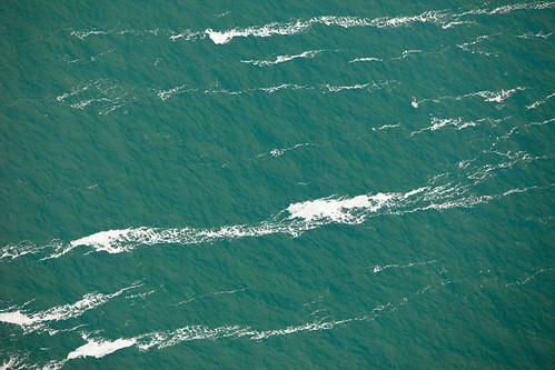
Whitecap waves in the Gulf of Mexico at this time can be an unfortunate occurrence. These waves can carry very strong currants which can be one of the greatest downfalls of this ever-expanding oil spill.

20100618-tedx-oil-spill-1076

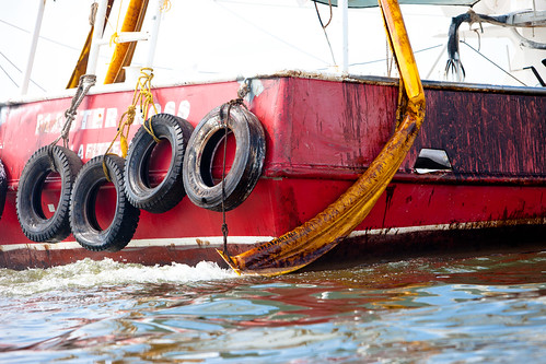
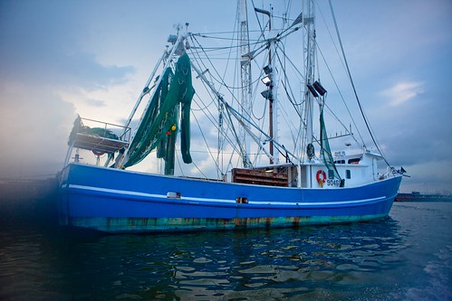
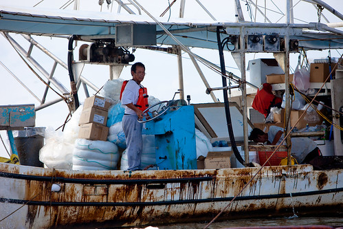
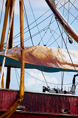
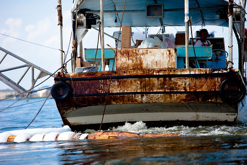
Boats that are currently working in the Gulf of Mexico can come back into harbor, after a day of sailing through the crude oil, looking absolutely horrific.

20100618-tedx-oil-spill-0983

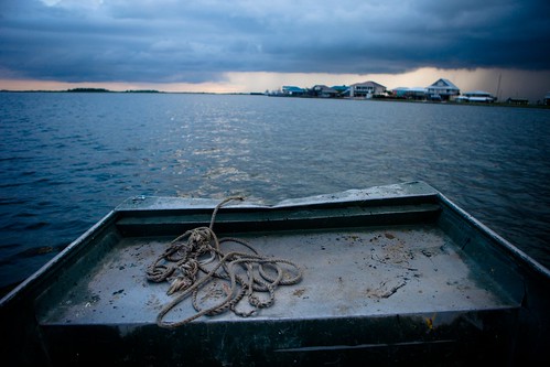
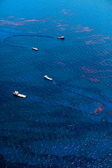
Two boats race towards each other in one of the dark waterways of the Southern Louisiana marshlands.

20100618-tedx-oil-spill-1741

A perfect day coasting in a fast boat along the blue waters of the Gulf of Mexico are becoming ones of the distant past. The effects of this oil spill will be felt for years to come.

20100618-tedx-oil-spill-1644

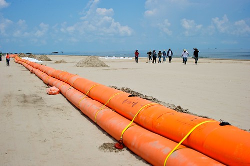
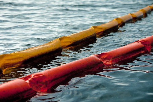
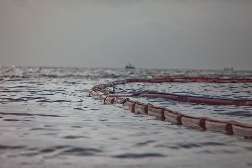
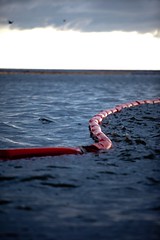
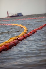
The first line of defense against the encroaching oil slick is surface protective boom that act as a barrier. Unfortunately the boom when unattended or left to the whims of weather changes can be highly ineffective.

20100618-tedx-oil-spill-1421 20100618-tedx-oil-spill-1798 20100618-tedx-oil-spill-1355

There are so many working parts of the cleanup effort in the Gulf of Mexico that it can seem disjunct yet potentially effective. Unfortunately the size of this oil spill makes is fairly difficult to see how effective any of these efforts are doing.

20100618-tedx-oil-spill-1171

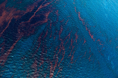
The darker colors within the oil designate the areas of the thickest crude oil.

20100618-tedx-oil-spill-1583

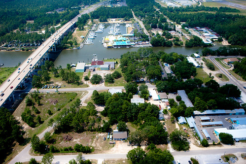
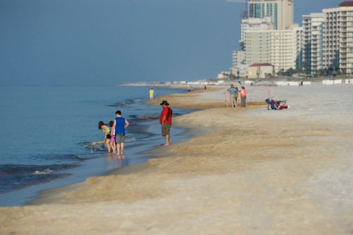
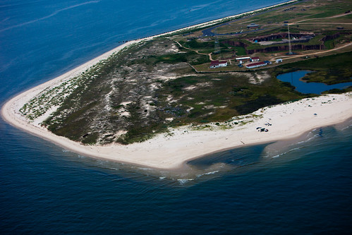
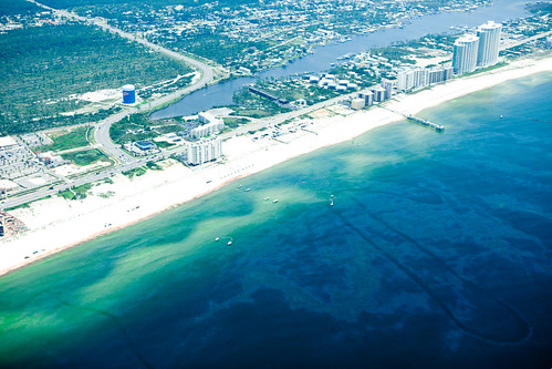
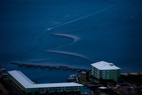
An aerial flyover view of Gulf Shore, Alabama shows the lively community and culture that is being directly affected by this oil disaster.

20100618-tedx-oil-spill-1649

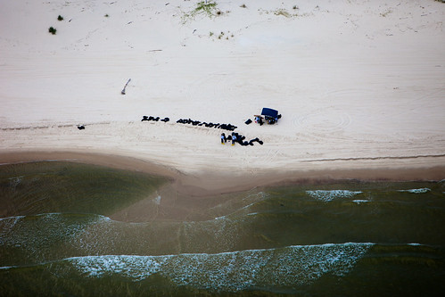
Black garbage bags line this white sand beach in Alabama. The only question on everyone’s minds is: WHAT IS IN THE BLACK GARBAGE BAGS?

20100618-tedx-oil-spill-1122

Catching the seaplane wing in this view of the Deepwater Horizon oil well really puts the grand size of the whole operation into perspective.

20100618-tedx-oil-spill-1529

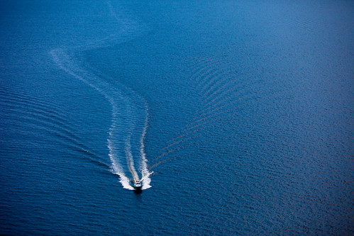
This picture perfect image of a jet setting boat gliding through clear water, upon closer inspection, is a cleanup boat heading out to the oil spill ‘Source’ along a seemingly untouched stretch of Gulf water.

20100618-tedx-oil-spill-1597

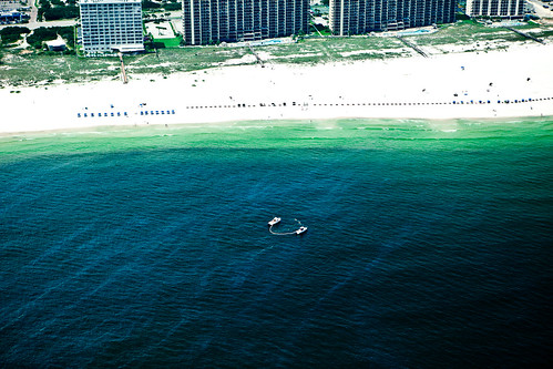
The beach in Gulf Shores, Alabama is lined up with beach chairs in anticipation of tourists’ arrival to the sandy shores. Yet the reality is that two boats are skimming oil off the top surface of the ocean just a few hundred yards out from the shoreline.

20100618-tedx-oil-spill-1875 20100618-tedx-oil-spill-1377 20100618-tedx-oil-spill-1855

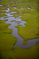
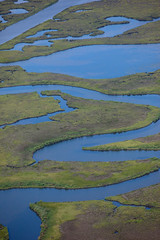
Breathtaking marshlands and their unprotected waterways are in danger of being infected with the fast moving oil slick. Two boats travel through the blue waters of the Gulf of Mexico and leave streaks through the iridescent oil settling on the surface.

20100618-tedx-oil-spill-1282

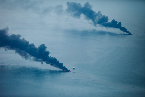
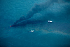
The site of the oil leak creates a massive dark cloud of oil that looms darkly over the entire cleanup operation.

20100618-tedx-oil-spill-1915

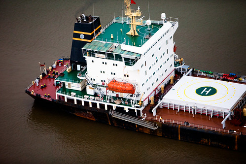
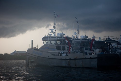
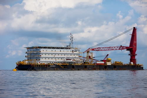
A large boat, carries accommodation units for workers’ working in the Gulf of Mexico, travels through murky waters.

20100618-tedx-oil-spill-0988

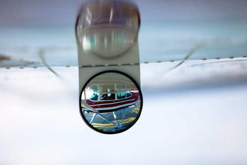
A small look into the seaplane that flew over the Expedition Team over the Gulf of Mexico.

20100618-tedx-oil-spill-1722

This ominous view is the very unsettling reality of the Gulf Coast situation. A long boat works tirelessly against the growing oil spill as small blobs of oil move quickly and steadily to the endangered marshland shores. The reality is that no one or nothing along the Gulf Coast is truly safe.

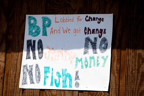
There is no two ways about this situation. There is a massive oil leak in the middle of the Gulf of Mexico, it has not been stopped and communities, cultures, wildlife and natural habitats are dying. The company that is in control of this leak is controlling information, spreading misinformation and continuing to endanger workers and wildlife on a daily basis.

The saddest part of this whole situation is that the OIL IS STILL LEAKING.

Please join one of the 115 TEDxOilSpill Meetups that are happening on June 28th.

Educate yourselves with some more information below:

Help Support the TEDxOilSpill Expedition Team

TEDxOilSpill event

Static Photography heads down to the Gulf with TEDxOilSpill Expedition

TEDxOilSpill Expedition Team Takes to the Skies

Louisiana Wildlife is Threatened as Oil Washes upon Coastal Shores

PBS Article: An expedition to the Gulf by Darron Collins

BP Sends PR Professionals to Gulf to Pretend to Be Journalists

Horrifying Video of Kids playing on oil-covered Destin Beach, Florida

Flashpoints: Pacifica Radio Station interview with Kris Krüg (starts at 32:38)

BP Press Release Theatre: Flying Higher

BP Press Release Theatre: Ballet at Sea

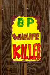
Free Prosecute BP Sticker

TEDxOilSpill Expedition photos by Kris Krüg

TEDxOilSpill photos by Duncan Davidson

TEDxOilSpill photos by Pinar Ozger

Louisiana Coastal Wildlife Threatened as Oil Comes Ashore in Beautiful Barataria Bay

Tuesday, June 22nd, 2010

20100616-tedx-oil-spill-0490

This past week the TEDxOilSpill Expedition team spent time in the Southern states that line the Gulf of the Mexico documenting the disaster that is slowly unfolding in Gulf waters. Exactly two months ago the Deepwater Horizon oil well owned by British Petroleum sprung a terrible leak thousands of miles under the water’s surface. The oil well has consistently leak millions of gallons of crude oil into the Gulf on a daily basis, with little to no stopping it. This catastrophe has affected so many areas of the Gulf Coast, not just touching upon the beaches and devastating the fisherfolk communities but also displacing hundreds of birds from their homes. Overall the amount of damage is infuriating.

20100617-tedx-oil-spill-0924

A collective call to action and response has emerged from this unsettling situation into the formation of the TEDxOilSpill event that is happening in Washington, DC on June 28th. The TED-inspired event will feature speakers from the NOLA areas, scientists who have studied in the Gulf of Mexico, policy makers about energy reforms on a government level and photos from the TEDxOilSpill Expedition. Photographers Kris KrügDuncan Davidson and Pinar Ozger, alongside the documentary words from Darron Collins, will curate the images for the event from this past week.

20100616-tedx-oil-spill-0500

One of the most heart wrenching communities that are affected by this disaster are the native wildlife to the Gulf Coast. Marine life, bird species, fish and mammals are all being caught in the effects of the oil spill, either by having their habitats destroyed or literally getting covered in crude oil. Either way the effects are monstrous and fatal in most areas. The wildlife are innocent bystanders and yet seem to be taking some of the biggest hits when it comes to the devastation. Bird and wildlife rehab centers have been setup through the Gulf to attend to the hundreds of birds that require serious oil cleaning.

tedx-oil-spill-0248

The Expedition team had the chance to head out into the Southern Louisiana marshlands with a local fisherman as a guide around some of the most inhabited bird islands. These photos depict the horror that is being committed in this area: stunning landscapes and overpopulated habitats are being destroyed by crude oil being washed ashore. The truly sad thing is that most of the wildlife has nowhere to go as many have young that have just hatched.

20100617-tedx-oil-spill-0834

Many of the boats that are helping with various aspects of the cleanup effort often come back into the harbors and bays with massive amounts of oil coverage. The unfathomable amount of oil that is being spilled into the Gulf is often unseen as the majority is at deep sea levels yet it is very easy to see the crude oil smeared across the sides, backs, and tops of the boats coming back in from the Gulf. Everywhere is being affected by this catastrophe.

Here are some of the photos by Kris Krüg of the journey to Bird Island:

20100616-tedx-oil-spill-0463

Dozens of laughing gulls take to the blue skies over a small island in the marshlands of southern Louisiana.

tedx-oil-spill-0348

This beautiful bird is a brown pelican and was just released off the endangered species list just over six months ago. These birds are one a few species that is feeling the effects of the oil spill the most.

tedx-oil-spill-0423

A beautiful underside view of a laughing gull in full flight.

tedx-oil-spill-0368

Often times these surface floatation devices called booms are the first line of defense against the travelling oil spill. Most coastal areas through the Gulf of Mexico are lined with them.

tedx-oil-spill-0371

From a distance it is surely hard to distinguish rocks from the hundreds of birds that cover the shores of this Southern Louisiana island. Many of these birds have nowhere to go and end up hanging out on the oiled banks.

tedx-oil-spill-0355

The oil spill that has come from the leak in the Deepwater Horizon oil well is primarily a deepwater leak. This means that the mass majority of the crude oil that is spilling into the Gulf is doing so for hundreds of miles below the surface. What oil that is seen on the surface is merely a fraction of the damage.

tedx-oil-spill-0279

A large boat awaits departure into the Gulf of Mexico in Grand Isle, Louisiana.

tedx-oil-spill-0322

In the early morning light a lone brown pelican flies just under a brewing storm cloud in Louisiana.

tedx-oil-spill-0407

Two large brown pelicans fly against a blue sky backdrop.

tedx-oil-spill-0263 tedx-oil-spill-0327 tedx-oil-spill-0242

While in Grand Isle, half of the TEDxOilSpill Expedition team was able to head out into the marshland waters with the assistance of Captain Joseph. The other half of the team, fiercekitty and Darron Collins stayed on the mainland.

20100617-tedx-oil-spill-0722

What appears to be oil pirates capitalizing on the oil spill are actually cleanup workers attempting to vacuum the crude oil out of the water. This technique is not very successful but Kevin Costner just released new machines that are much better at this task.

20100617-tedx-oil-spill-0652

Boom that is used as a defense against the migrating oil is only effective when it stays in the water. Unfortunately the boom is fairly lightweight and is susceptible to movement by weather conditions.

20100617-tedx-oil-spill-0910

Many local Gulf residents are frustrated by the mere fact that the oil spill has singlehandedly destroyed the main livelihood of the fisherfolk communities. The oil spill had the disastrous misfortune of happening at the beginning of the fishing season.

20100617-tedx-oil-spill-0616

Brown pelican babies congregate on this small island in Grand Isle, Louisiana. Many of these birds are very young which proves to be an extremely vulnerable stage of life as their survival rate is being compromised by the destruction of their habitat.

tedx-oil-spill-0302

The early morning brings in an early storm to the shoreline of Grand Isle in Louisiana.

tedx-oil-spill-0244

Many of the fisherfolk have been unable to fish for this year’s season due to the contaminated Gulf waters. In lieu of their normal liveliood, many fisherfolk have been hired for the cleanup response instead.

20100617-tedx-oil-spill-0818

The aftermath of a boat that has ventured into the Gulf of Mexico. In many coastal harbors it is commonplace to see such boats as this oil-caked one.

tedx-oil-spill-0425

A single laughing gull travels through the stormy skies of Grand Isle, Louisiana.

20100617-tedx-oil-spill-0743

A rogue pirate flag flies high on this supplies barge.

tedx-oil-spill-0365 tedx-oil-spill-0235 tedx-oil-spill-9956

More boom, a protesting poster and an island that is shaped like a seahorse.

20100617-tedx-oil-spill-0752

These boats in the past were used for shrimping but have been put out of commission due to the oil spill. For the past two months they have been scooping up surface oil instead.

20100616-tedx-oil-spill-0518

A brown pelican attempts a landing in a sea of oil-soaked marsh grasslands.

20100616-tedx-oil-spill-0496

Two brown pelicans fly side by side in the blue sky. These relatively small pelicans can have wingspans up to 8 feet.

20100617-tedx-oil-spill-0640

A brown pelican swims low to the oily waters in Grand Isle, Louisiana.

20100617-tedx-oil-spill-0893

Many different groups and organizations are taking part in the Gulf cleanup effort. Here a US Coast Guard boat makes its way out into the waters.

20100617-tedx-oil-spill-0881

A sign just off the shores of the marshlands states a warning to watch out for petroleum pipeline crossing. It is unbelivable how much of the Gulf of Mexico is being drilled for oil.

20100617-tedx-oil-spill-0909 20100617-tedx-oil-spill-0798 20100617-tedx-oil-spill-0907

More protest signs and severely oiled boats line the waterways in Grand Isle, Louisiana.

20100617-tedx-oil-spill-0663

When effective the boom in the water acts as a sponge for the crude oil that reaches the top surface. Once the boom is heavy with oil, it is replaced.

20100617-tedx-oil-spill-0604

Despite the environmental destruction that is going on around them, young pelican parents come back to their island habitat to feed their very young offspring.

20100617-tedx-oil-spill-0762

Real estate and housing prices in coastal cities have sky rocketed in the past two months due to the oil spill. Thousands of cleanup workers are working just in the coastal areas, for sometimes weeks on end, and they all need housing accommodations. Some have resorted to having housing on the waters like this barge unite.

20100617-tedx-oil-spill-0658

An oil covered buoy gets stuck in the boom.

20100617-tedx-oil-spill-0814

The back end of this boat, which normally is white, was soaked by the crude oil from the Gulf. There are some parts of the oil spill that coat the water in this dark brown color.

20100617-tedx-oil-spill-0633

Such beauty in such a devastatingly dark place. A streak of hot pink flies through the air as a brightly colored Roseate Spoonbill glides in through the sky, high above the oiled island below.

The most heartbreaking realization about this whole situation is that the oil is still leaking into the beautifully diverse and rich Gulf of Mexico. The facts and images are terribly overwhelming and can leave one feeling truly helpless. The effects of this catastrophic event will be felt for years to come.

For more information:

Help Support the TEDxOilSpill Expedition Team

TEDxOilSpill event

Static Photography heads down to the Gulf with TEDxOilSpill Expedition

TEDxOilSpill Expedition Team Takes to the Skies

TEDxOilSpill Expedition photos by Kris Krüg

TEDxOilSpill photos by Duncan Davidson

TEDxOilSpill photos by Pinar Ozger

Day 7: Our Last Day in the Gulf, For Now

Monday, June 21st, 2010

The last day of our expedition found us waking up at 5:30AM in a La Quinta in Gulf Shores, Alabama. We had returned for a final few hours on the beaches here after witnessing oil on the beach and water the previous day from the air. We didn’t have long—we had to be back at the airport in New Orleans just after lunch—but we wanted to see what things looked like from the ground.

Oiled Beach in Gulf Shores, Alabama

We arrived right at high tide. That meant that the bulk of the oil on the beach that we saw the day before was covered. The sand all along the water line, however, was oil stained. You could look out to sea and see the sheen of oil. If you didn’t know what you were looking at, you might mistake it for something else. But we’d seen it from the air and knew what we were looking at. It made us cringe to see tourists walking barefoot along the beach and out in the water. It horrified us when we spotted a family with a few children using nets to fish something out of the water. I couldn’t quite spot what was in their nets, but they took whatever it was with them.

A family uses nets to fish things out of the water.

At one point, we talked with one of the safety officers for the clean up crew. He had served in Iraq and as we talked about his service history, he said that he felt he was doing his country more of a service on the beaches in Alabama than he did oversees. He also said that he had seen the test results of the water and while most of the aromatics has evaporated from the oil by the time it reached the Alabama coast, there’s no way he’d go in the water or walk on the beach without foot protection. But, the local hotels and tourism boards were attempting to encourage a business as usual attitude and at least some people were buying it.

Workers on the beach in Gulf Shores, Alabama

After spending a few hours scouting the beaches, we drove back to New Orleans and all took our separate flights home. We’ve all got thousands of photographs to sort through, stories to write about, and our own personal emotional states to tend to. This hasn’t been an easy week.

We’re proud of what we’ve been able to accomplish here on the Gulf of Mexico. We’ve seen the surface scope of this disaster and we’re going to bring our first hand account to TEDxOilSpill next Monday. It’s horrifying and terrible—all the more so since we know that we’re only seeing a fraction of the effects of this disaster. Most of the oil still lurks underwater. Most of the wildlife that’s being affected lives under the surface. It’s a sobering thought we continue to come back to.

Speaking for myself (Duncan), I can say that I want to go back to continue working this story. We’ve done an amazing amount of work in a week, but with that experience, I’m sure that we could do even more. As well, the effects of this disaster are not over. This story will be a long one and as the attention on it inevitably wanders elsewhere, it’ll need more coverage. I hope that the team, either together or individually, can return to document more of the effects here.

Photos credit: James Duncan Davidson

Day 6: Our Second Flight Over the Gulf Coast

Sunday, June 20th, 2010

Yesterday, we had five people on our team. Today, we’re down to four. Darron had to make it home for the weekend and some much deserved downtime leaving the rest of us one more full day in the Gulf States. We used it to arrange another flight over the Gulf of Mexico with Pinar, Kris, and Duncan.

We debated intensely over our routing. Should we head back out to the source? Should we spend more time over the wetlands of Louisiana? Or, should we follow a tip we’d heard from somebody that had flown over Orange Beach that indicated oil was just offshore? In the end, we decided to fly a triangle route from New Orleans out to the source and then up to Gulf Shores. It was a risk, especially at $570/hour of airtime, but we figured it was a risk worth taking.

With a last check of the weather—which showed storms over the Gulf, but based on the patterns, we figured we could time things to miss them—we set out. As we approached the source, we spotted the fires burning off gas from about 20 miles out and saw oil in the water at about the same distance.

Flying over the source, we saw amazing amounts of heavy oil in the water and spent a few orbits over both the main site as well as a few other boats in the area. The smell of oil and gas over the source is intense. It’s like standing next to a bucket of gasoline sitting next to a leaky propane tank. Flying around it—and knowing that the true source of the oil is a mile underwater—is like flying over the gates of a watery hell.

Flying north from the source to Gulf Shores, we saw oil ranging from sheen to much heavier all the way to the coast and as far as the eye can see in both directions. It’s over a hundred miles from the spill site to the coast of Alabama. There’s no good way to describe how huge an area is impacted.

A ship in the oil. (Photo: Kris Krüg)

When we arrived at Gulf Shores, we saw the oil coming up on the beach. Beaches that had been relatively clean a few days ago, when we were last there, now were stained with oil. Skimmers were operating right off the shore.

Oil in the water and on the beach in Gulf Shores, Alabama (Photo: Pinar Özger)

Amazingly enough, a few miles down shore where oil wasn’t yet on the beach, but within hundreds of yards, we spotted swimmers in the water. We were flabbergasted. If they could see what we saw, there’d be no way they would be in that water.

Once we returned to New Orleans, we huddled for a bit and decided to return by land to Gulf Shores so that we can document the oil coming on shore from the beachside. That will be tomorrow morning’s task.

Photo Essay: TEDxOilSpill Expedition Team Takes to the Skies, Documents Damage to Southern Louisiana Marshlands

Saturday, June 19th, 2010

Burning Off The Surface Oil From BP's Deepwater OilSpill

The last few days have been a non-stop journey through the coastal area of New Orleans and the Southern Louisiana Marshlands for the TEDxOilSpill Expedition team. The team of photographers, videographer and writer have been exploring the land and the sky in order to understand the story of the oil crisis here in the Gulf. A couple thousand photos and multiple blog posts later, the team is gathering media coverage from a witnessing POV for the June 28th TEDxOilSpill event in Washington, DC.

tedx-oil-spill-9153

In the first couple of days of the expedition, the team divided their time through Mississippi and Alabama, following the expanding oil spill coverage and documenting the communities of the Gulf Coast states that have been affected. The last few days have had a heavy focus on Louisiana, especially with the team paying close attention to the southern marshlands. Unlike the rest of the Gulf Coast beaches, these marshlands have been hit fast and hard from the unending oil spill, with devastation to the natural wildlife being particularly horrific.

(more…)

TEDxOilSpill Expedition Funding Update

Friday, June 18th, 2010

When we first conceived of the idea of doing an expedition to the Gulf of Mexico, we knew we had to move fast. So we did. We planned the trip in a week and found ourselves in Louisiana the next. As part of this rapid-fire planning and execution, we set up a PayPal donation link to help fund our expedition. We’ve been humbled by the response and the support has literally been the wind beneath our wings as we flew in a seaplane across the Gulf of Mexico yesterday.

When we announced the PayPal link, we committed to using every scrap of money raise to pay for expenses related to the expedition. We also committed to transparency and reporting what the donations were used for. Here’s a quick update to give you an idea of where we stand.

In the four days since we kicked off the PayPal link, we’ve raised a bit over $5700. In the same period of time, we’ve racked up expenses as a team of $10,010 with probably another $2500 to go, the majority of which will be our second seaplane flight tomorrow.

As you can see, your contributions have helped in a major way, and we’re grateful. They show that the community of people rallying around the TEDxOilSpill event and the general public really care about this news and support our commitment to bring more coverage to this ongoing environmental disaster whose effects will be felt for a very long time to come.

As we work in the Gulf, we’re very aware that we’re working for you and are looking to bring you our view of the situation and to share it with the world. We’ve been posting photos and blog posts as we go. We’ll present even more at TEDxOilSpill. And, everyone on the team is committed to putting out additional work based on the photos and stories captured in the Gulf of Mexico this week.

If you’ve donated, thank you so very much. You rock and we’d love to shake your hand, give you a hug, and otherwise show our appreciation.

If you’d like to help us out with the rest of our expenses, please use the PayPal donation link.

Last, if you are somebody at an organization that would like to respond to the general public’s amazing contribution and match it, please get in touch.

Again, everyone on the team here in the Gulf of Mexico—Duncan, Kris, Pinar, Darron, and Danielle—are humbled by your show of support and we thank you.

Photo credits: Kris Krüg, Pinar Özger, and James Duncan Davidson. Click through any photo see it larger on Flickr.

Air Traffic Control Over the Gulf

Friday, June 18th, 2010

One of the challenges in flying out to the Deepwater Horizon site is getting clearance to fly into the restricted airspace in the Gulf of Mexico. The temporary flight restriction (TFR) has been used to keep lots of flights out in the past. Luckily, we’re working with an operator that knows how to use their connections to get flights approved into the TFR. Once approved, the flight is issued a “squawk code” that is transmitted by the aircraft to let the people monitoring the restricted area know we are supposed to be there.

Even with all that in place, it sometimes doesn’t mean that everything goes smoothly. As we flew out to the Deepwater site, our pilot Dicky was in constant contact with a Navy P3 Orion—a mini AWACS aircraft—orbiting high above the gulf keeping track of everyone.

When we departed the Deepwater site and Dickie communicated to the Orion (call sign “Omaha 99″) our intent, the controller came back quite quickly saying, “You’ve created a hell of a ruckus with your flight today. We’ve got flights in and out of this airspace and you’ve been interfering with them.” We got chewed out for several minutes straight. The funny thing is that we hadn’t been given any advisories or instructions by the controllers the entire time we were orbiting the site. Furthermore, there were no other flights that came or left the immediate area while we were there. We’d have photographs of them if there were.

Something tells me that we weren’t quite welcome there and our presence was merely tolerated. But we were there in any case and we weren’t there to make friends.

Photos: James Duncan Davidson

Day 4: Team Heads to Baton Rouge and Oil Spill Source

Friday, June 18th, 2010

Our four-geek-one-Pennsylvania-Dutch-cobbler Oil Spill Expedition team has really gelled over the past four days. But today we had to split up to cover more ground and air. KK, Pinar and Duncan took to the wing to fly to “the source” and buzz the islands in Barataria Bay to capture what we all need to be seeing more of. I got a sneak peek in the geek truck on the ride back down to Grand Isle and heard the crazy stories, but will leave it to them to tell it firsthand.

Daniel and I headed west on I-10 to Baton Rouge, LA to sit in on an oil spill rally. Here’s my take on that event.

10am

My rental car – a blood red Ford Escape – cost $12.00 for the day.  I didn’t correct their mistake.  We’d have to rush to make the 11.30 kick-off of the “march on the Louisiana Capitol building,” which would start at the old capitol building and end on the steps of the new one.  But actually we had plenty of time because there was a scheduling error and last-minute change of plans which moved the march until Friday but kept the rally for today.  We didn’t quite understand the strategy but wanted to see how it would evolve.

Louisiana State Bird

It’s strange.  If ever there was a time for this country to take to the streets I would think it would be now.  A few did.  But not many.  I’m not a child of the 60s nor have I spent much time pounding the streets and raising hell in the 90s or in this decade, but this didn’t quite meet my expectations.  Part of it I suppose was the late change of plans.  Part of it was the mid-day heat and the mid-day jobs.  And part of it, brought to my attention by my fellow expedition member Kris Krug, is the fact that motivations have changed.

(more…)

TEDxOilSpill
June 28, 2010
Washington, DC